Posts

Image Enhancement Module 6 Remote Sensing 4035

Image
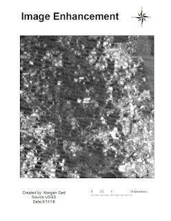
Module 6 lab took us the through the use of many different types of filters in order for a user to sharpen or make prominent different features that may be contained in an image. The example below if the sharpened Fourier filter enhancement. It is not as clear as I would like it to have been but this filter is going to take a lot of practice to use effectively.

Module 5a Erdas Imagine RS 4035

Image
This week we worked in Erdas Imagine to manipulate raster images. It was interesting learning the different applications you can use as opposed to Arc Mapping. I enjoyed being able to change the spectral bands in order to change the topographical features that you wanted to stand out.

Module 2 Lab 4035

Image
In module two be were asked to create three maps identifying texture and tone, shape and size, and distinguishing between true color and false color. Below are my three and the last is incomplete and some labeling is obviously off but was not able to figure out how to fix it before images due.

Week 12 GeoReferencing GIS 4043

Image
In week 12 Georeferencing it was a bit challenging at first to create control points that overall had a low RMS reading. But after an hour or so practicing it got easier. The second raster image that I needed to fit to the first one did end up a bit warped in the end but I had to move on due to time issues. Images from my original data frame disappeared and due to time constraints I have to just create a map from what I had left.

Vector Analysis 2 Week 10 GIS 4043

Image
This week we used and learned about buffering, overlay, and union of vector and raster data. We also learned to write script in arcpy-It took me a couple of errors before I got it completely right but it is a very useful tool if you have multiple items that need to be ran because for one being able to copy and paste and being able to adjust little bits of information in the script. Though we just learned the basics of buffer and overlay I look forward to delving deeper into the capability of these tools.

Data Search GIS 4043

Image
This week in data search we were to collect our own data and project it into a single projection to be used in a map. I was assigned Nassau County and collected a DOQQ (the NE region) a DEM and five vector layers to be used. I chose to re-project layers into the same projection changing the "03" designation of North into "01" East as that was the quadrant I was using. I ran into some problems with some layers showing through and finding land that was not township range in the data base provided but for the lack of time had to submit what I had.

Projections Part 2 GIS 4043

Image
In projections part 2 we learned the difference between defining a projection and actually re-projecting a projection. I gathered quads from the labin's website and those I had to define the projection because when I looked in the ArcCatalog they had no existing spatial information. When obtaining county boundaries and major roads those files had to be re-projected as they already had a defined projection. My projections came out all in the specified coordinates but end map could have used a little more work.